


0 of 0
TL;DR
This is a mapping resource based on TES III cell exports and compiled/edited with GIMP.
Tamriel Rebuilt, Skyrim: Home of the Nords, and Province: Cyrodiil swear by it.
Short enough; did read
The Elder Scrolls is quite infamous for its fluid canon (or open source canon, as some like to think of it). One particular "feature" are the official game maps.
Skyrim infamously features a First Era Dwemer map with modern borders and existing Vvardenfell. ESO features a total revision of Morrowind's coastline and abolishment of Winterhold and Blacklight, plus Bleakrock Isle out of nowhere where Solstheim (in itself only added with TES III) should have been.
Cities move halfway across the province (like Markarth Side) or are renamed for no apparent reason (like Markarth "Side").
Even Tamriel itself is not safe - where the current shape of the continent was shipped with TES IV, it was fundamentally different from the one that shipped with TES I.
So, where does the Gridmap come in?
Back in the olden days before TES IV: Oblivion, there was only one Tamriel map after the Arena one and that was the one created by Arthmodeus. He's immortalized on TIL, his map forms the basis for the Elder Kings Crusader Kings II mod, and, even 18 years later, his map is influential enough to still serve as an easy foil for everyone who wants to take pot shots at the concept of fan maps.
The TES III Province mods - Tamriel Rebuilt (including the Silgrad Tower splinter and the latter's successor projects), Skyrim: Home of the Nords, Province: Cyrodiil, Project Outreach, and High Rock 427 (which either died, unified under the Project Tamriel banner, or both) - were built on the assumptions and scale of Arthmodeus' map and with it the older Arena shape.
Over time, shape and planning drifted away from even that shape and in 2015, there was no correlation between unofficial concept maps and actual in-game implementation anymore. Nevermind project-specific planning maps. The oldest existing one for TR was still the only one that existed and it was outdated as sin. The ones for SHotN had no regular cell size and P:C's was developed in isolation.
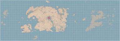
The Gridmap is a modern reinvention of these planning maps. Based on the 256x256 bmp exports generated by CreateMaps, it extrapolates from the content generated by Tamriel Rebuilt and the Project Tamriel mods and their planning. Python scripts compress the individual bmp files into 40x40 cells and everything else is built on top of good eyes, steady hands, paths, and filters.
Additional landmasses beyond the Province mods are by and large based on other existing, low-profile mods - such as Roscrea, Esrionet, and Yneslea, or on maps LadyNerevar has posted before (such as the Uriel V Propaganda map, the Tamriel Landmass comparison, and Artaeum) as well as the Redguard map.
What exactly can you download here?
Full in-dev project maps with all layers are not available here, for obvious reasons. This mod page includes downloads for:
Buyer, beware!
You will need GIMP 2.10 to edit the maps. There is not currently a full global key, though the gridmap may be updated to include one in the near future. You can ask on the #gridmap channel in PT or TR's discord server if you have questions.
This is a mapping resource based on TES III cell exports and compiled/edited with GIMP.
Tamriel Rebuilt, Skyrim: Home of the Nords, and Province: Cyrodiil swear by it.
Short enough; did read
The Elder Scrolls is quite infamous for its fluid canon (or open source canon, as some like to think of it). One particular "feature" are the official game maps.
Skyrim infamously features a First Era Dwemer map with modern borders and existing Vvardenfell. ESO features a total revision of Morrowind's coastline and abolishment of Winterhold and Blacklight, plus Bleakrock Isle out of nowhere where Solstheim (in itself only added with TES III) should have been.
Cities move halfway across the province (like Markarth Side) or are renamed for no apparent reason (like Markarth "Side").
Even Tamriel itself is not safe - where the current shape of the continent was shipped with TES IV, it was fundamentally different from the one that shipped with TES I.
So, where does the Gridmap come in?
Back in the olden days before TES IV: Oblivion, there was only one Tamriel map after the Arena one and that was the one created by Arthmodeus. He's immortalized on TIL, his map forms the basis for the Elder Kings Crusader Kings II mod, and, even 18 years later, his map is influential enough to still serve as an easy foil for everyone who wants to take pot shots at the concept of fan maps.
The TES III Province mods - Tamriel Rebuilt (including the Silgrad Tower splinter and the latter's successor projects), Skyrim: Home of the Nords, Province: Cyrodiil, Project Outreach, and High Rock 427 (which either died, unified under the Project Tamriel banner, or both) - were built on the assumptions and scale of Arthmodeus' map and with it the older Arena shape.
Over time, shape and planning drifted away from even that shape and in 2015, there was no correlation between unofficial concept maps and actual in-game implementation anymore. Nevermind project-specific planning maps. The oldest existing one for TR was still the only one that existed and it was outdated as sin. The ones for SHotN had no regular cell size and P:C's was developed in isolation.
The Gridmap is a modern reinvention of these planning maps. Based on the 256x256 bmp exports generated by CreateMaps, it extrapolates from the content generated by Tamriel Rebuilt and the Project Tamriel mods and their planning. Python scripts compress the individual bmp files into 40x40 cells and everything else is built on top of good eyes, steady hands, paths, and filters.
Additional landmasses beyond the Province mods are by and large based on other existing, low-profile mods - such as Roscrea, Esrionet, and Yneslea, or on maps LadyNerevar has posted before (such as the Uriel V Propaganda map, the Tamriel Landmass comparison, and Artaeum) as well as the Redguard map.
What exactly can you download here?
Full in-dev project maps with all layers are not available here, for obvious reasons. This mod page includes downloads for:
- The world map .xcf, with all project maps' layers merged into each other.
- World map .png images -- one with regions, one without.
A tutorial file with various information.There is an old one in the archived files, but it is quite outdated. Tani is working on a new one ... eventually.
Buyer, beware!
You will need GIMP 2.10 to edit the maps. There is not currently a full global key, though the gridmap may be updated to include one in the near future. You can ask on the #gridmap channel in PT or TR's discord server if you have questions.