


0 of 0


About this mod
Full-color Microsoft Excel spreadsheets which show the topography of all playable TESIV world maps. The maps were generated directly from in-game data and can be used to locate land tears (broken seams between game cells).
- Permissions and credits
- Changelogs
TESIV World Topography Maps
These files are Microsoft Excel spreadsheets which show the topography of all 25 playable worlds in TESIV: Oblivion. The maps were generated directly from TESIV data, and include Oblivion, Shivering Isles, and all DLC expansions.
File Descriptions
There are three files: Tamriel-Heightmap2, Tamriel-Unused Maps, and Tamriel-Data.
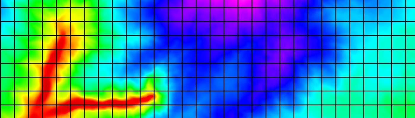
Tamriel-Heightmap2 uses a sophisticated color scheme to show the height of all 34 million Z-coordinates in TESIV, from the lowest point (-1024, black) to the highest (+6581, white). The contrast is pretty good even on relatively flat maps.
Tamriel-Unused Maps displays all of the world maps defined in TESIV but not actually used in-game. (Your character will end up visiting several of these worlds during a playthrough, but the heightmaps are never actually used.)
Tamriel-Data only shows the raw data and results; it doesn't contain any maps. All three files include a list of the 103 land tears that exist in vanilla TESIV.
How to Use
--You will need Microsoft Excel 2007 or newer to view the files properly. You can request other formats in the Discussions thread, but I cannot guarantee I'll be able to provide them.
--When you first open the file, it'll ask whether to Enable Macros. You can leave them disabled, as they were used to build the maps.
--Each of the 25 playable and 59 unplayable worlds has its own tab. The last several tabs contain the raw data and results.
--The TamrielDLC and TestAyleidDLC maps show changes made by Knights of the Nine and other DLC packages.
--In each map, you'll see colored or gray cells. Colored cells had heightmap (Z) data, while gray cells exist in the game but have no Z data.
--Each black-outlined box represents one game cell. The dark gray border on some maps (Tamriel, SEWorld, CamoranParadise, PalePassWorld) represents the playable boundary on those maps, i.e. the point at which your character is told "You cannot go that way; turn back."
--Click on a cell to see its Z data. A comment will pop up listing the cell's coordinates and, if applicable, Editor ID.
--Land tears (cases where adjacent cells's borders are at different heights, causing in-game ground gaps) are indicated with white text and the letter "T". You'll have to zoom in, or do a search for "T", to find them. The "Tears" tab contains more info about these. Altogether there are 103 land tears in vanilla Oblivion, though they vary in size and degree, and all but 9 are outside of playable areas.
--On the Summary tab, you'll see some stats for the 103 reported tears. "Max" is the largest difference, in Z units, between the two cells. The larger the number, the taller the gap. "Avg" is the average distance, in Z units, between the two cells. "Length" is how wide the gap is - it can be up to 33 units across.
Changes in Version 1.01, 7 March 2016
--Improved the color scheme so that contrast is good even on relatively flat maps, while still using the same color scheme across all maps.
--Added maps of all 59 unplayable worlds, so one map of every location defined in TESIV is now available.
--Improved the zoom factor so you can see more of each map when you zoom all the way out.
--Clearly marked each land tear with white text and the letter "T", to enable searching for tears.
--Added in-game boundaries in dark gray. These are the locations at which your character is told "You cannot go that way; turn back."
--A couple of minor fixes
These files are Microsoft Excel spreadsheets which show the topography of all 25 playable worlds in TESIV: Oblivion. The maps were generated directly from TESIV data, and include Oblivion, Shivering Isles, and all DLC expansions.
File Descriptions
There are three files: Tamriel-Heightmap2, Tamriel-Unused Maps, and Tamriel-Data.
Tamriel-Heightmap2 uses a sophisticated color scheme to show the height of all 34 million Z-coordinates in TESIV, from the lowest point (-1024, black) to the highest (+6581, white). The contrast is pretty good even on relatively flat maps.
Tamriel-Unused Maps displays all of the world maps defined in TESIV but not actually used in-game. (Your character will end up visiting several of these worlds during a playthrough, but the heightmaps are never actually used.)
Tamriel-Data only shows the raw data and results; it doesn't contain any maps. All three files include a list of the 103 land tears that exist in vanilla TESIV.
How to Use
--You will need Microsoft Excel 2007 or newer to view the files properly. You can request other formats in the Discussions thread, but I cannot guarantee I'll be able to provide them.
--When you first open the file, it'll ask whether to Enable Macros. You can leave them disabled, as they were used to build the maps.
--Each of the 25 playable and 59 unplayable worlds has its own tab. The last several tabs contain the raw data and results.
--The TamrielDLC and TestAyleidDLC maps show changes made by Knights of the Nine and other DLC packages.
--In each map, you'll see colored or gray cells. Colored cells had heightmap (Z) data, while gray cells exist in the game but have no Z data.
--Each black-outlined box represents one game cell. The dark gray border on some maps (Tamriel, SEWorld, CamoranParadise, PalePassWorld) represents the playable boundary on those maps, i.e. the point at which your character is told "You cannot go that way; turn back."
--Click on a cell to see its Z data. A comment will pop up listing the cell's coordinates and, if applicable, Editor ID.
--Land tears (cases where adjacent cells's borders are at different heights, causing in-game ground gaps) are indicated with white text and the letter "T". You'll have to zoom in, or do a search for "T", to find them. The "Tears" tab contains more info about these. Altogether there are 103 land tears in vanilla Oblivion, though they vary in size and degree, and all but 9 are outside of playable areas.
--On the Summary tab, you'll see some stats for the 103 reported tears. "Max" is the largest difference, in Z units, between the two cells. The larger the number, the taller the gap. "Avg" is the average distance, in Z units, between the two cells. "Length" is how wide the gap is - it can be up to 33 units across.
Changes in Version 1.01, 7 March 2016
--Improved the color scheme so that contrast is good even on relatively flat maps, while still using the same color scheme across all maps.
--Added maps of all 59 unplayable worlds, so one map of every location defined in TESIV is now available.
--Improved the zoom factor so you can see more of each map when you zoom all the way out.
--Clearly marked each land tear with white text and the letter "T", to enable searching for tears.
--Added in-game boundaries in dark gray. These are the locations at which your character is told "You cannot go that way; turn back."
--A couple of minor fixes