


0 of 0
File information
Created by
RomanDesignUploaded by
romandesignVirus scan
Some manually verified files
About this mod
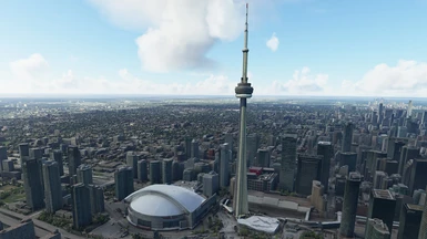
This pack features hand-picked key areas around Greater Toronto Area to compliment default photogrammetry and autogen areas and default terrain fixes for maximum VFR flight and IFR approaches enjoyment.
- Permissions and credits
- Mirrors
- Donations
Version 2.2 - with custom-modeled and painted TTC buses (yes, I went totally bonkers!!!) and CoachCanada buses, new Wilson station at Downsview with trains, multiple mesh and terrain fixes and new objects.
File size: 876Mb
If you like this scenery, take a look at my new release:
CNC3 Brampton - Caledon Airport PRO 1.0 is now available at https://flightsimulation.romandesign.ca
DESCRIPTION
This pack features hand-picked key areas around Greater Toronto Area to compliment default photogrammetry and autogen areas and default terrain fixes for maximum VFR flight and IFR approaches enjoyment.
FEATURES
SCENERY
DONATIONS / SUPPORT
If you want to support my other creative project, check out Progress Report - my sci-fi technothriller novel which you can read and download for free. You can also support my projects through this website usual Donation interface.
INTRODUCTION
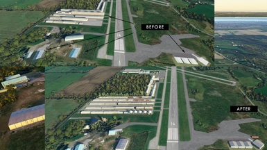
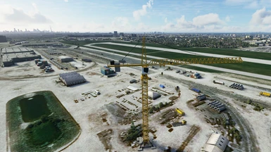
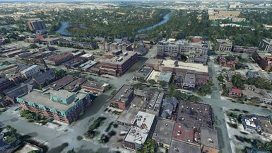
The areas of the pack are very close to CYYZ - Toronto Pearson International Airport. Toronto has photogrammetry in MSFS, and Toronto Island CYTZ is a custom airport, but photogrammetry ends outside of Toronto proper, and starts again around Burlington and Hamilton area. Many important Greater Toronto Area VFR landmarks and POI are left to autogen.
I've decided to correct that as much as I can, as well as fix some glaring terrain errors, such as a huge and long weird "aqueduct" type ridge with a Humber river on top.
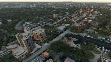
I'm aiming for making the whole GTA area comfortable for VFR flights and authentic CYYZ approaches and departures, and make local GA flights more enjoyable. So far I've done Oakville downtown and now Missisauga downtown. Meshes optimized and heavily edited, textures color corrected to blend with autogen building.
INSTALLATION
Unzip into Community folder. There are 3 zip files, each corresponds to a major area. They are designed to work together, so install all three. After installation your Community folder should have three new subfolders: /oakville/, /mississauga/ and /toronto/.
DISTRIBUTION
This free creation contains content from Google Maps or Google Earth. In accordance with Google Terms of Services and especially point 2.2 of Google Maps/Google Earth Additional Terms of Service, this creation is based on « fair use » or « fair dealing » of the data provided by google throught its services. No commercial use or any gain is or will ever be made by the author of this creation, who doesn’t own anything regarding google assets but a simple user Licence. According to the following document https://www.google.com/intl/en-GB/permissions/geoguidelines/, the author is freely sharing a creative application of Google Maps or Google Earth. The author will not recieve any form of retribution for sharing his work. If this content would be found somewhere where it is provided in exchange of money or any kind of retribution, I would not be with the consent of the author.
As Google stated it cannot answer to any direct demand about a particular creative use of its properties, like stated in the « written permission » paragraph of the same document, to verify if its complying with its Term of Services, and as it is economically unreasonable for the casual creator of this content to ask for a costly legal analysis of its creation like proposed in the « Fair use » paragraph of the document, the author of this creation will stop sharing it freely and destroy any trace of it at first demand from Google, in accordance with the paragraph « Taking action in case of problems » of the Google Terms of Service about « advance notice » provided « when reasonably possible ».
File size: 876Mb
If you like this scenery, take a look at my new release:
CNC3 Brampton - Caledon Airport PRO 1.0 is now available at https://flightsimulation.romandesign.ca
DESCRIPTION
This pack features hand-picked key areas around Greater Toronto Area to compliment default photogrammetry and autogen areas and default terrain fixes for maximum VFR flight and IFR approaches enjoyment.
FEATURES
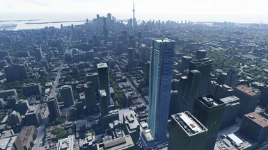
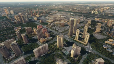
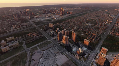
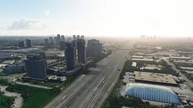
- All areas implement 3 LOD levels, minimizing FPS impact
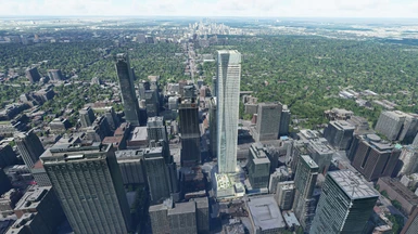
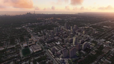
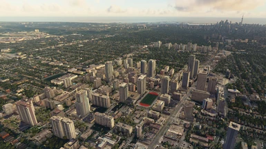
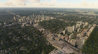
- Photogrammetry is heavily edited and texture color, contrast and brightness is carefully corrected to match surrounding autogen scenery
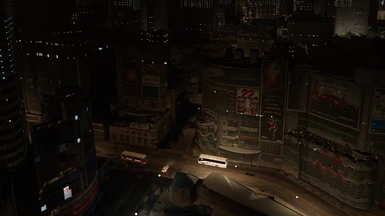
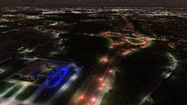
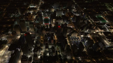
- Custom night lighting, including flashing strobes on tall buildings and facade illumination
- Stock buildings, cars, trains, antennas and other objects are added to enrich the scenery
SCENERY
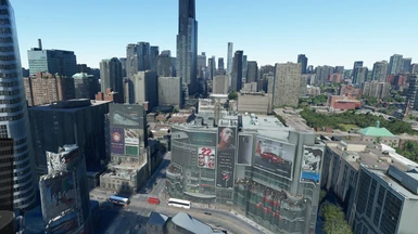
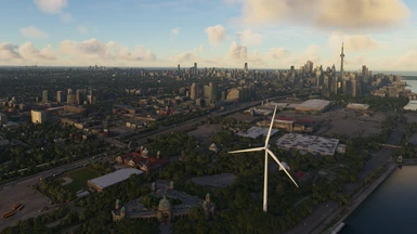
- CN Tower - improved detailed model, realistic night lighting, red and white strobes
- Bloor One building (missing in default photogrammetry)
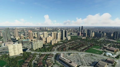
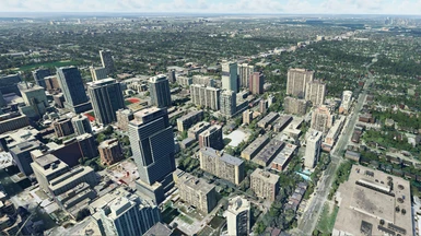
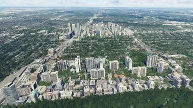
- Midtown highrise area
- North York - Younge street highrise area
- Humber Bay Shores, Humber Bay Arch Bridge
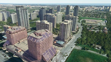
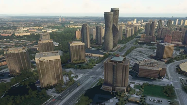
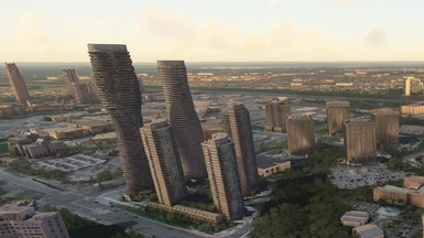
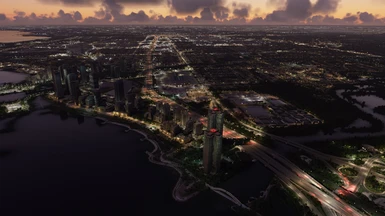
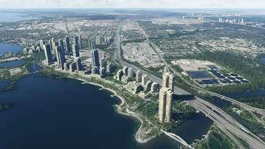
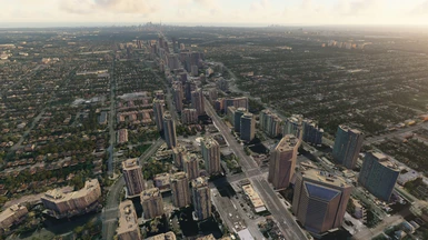
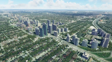
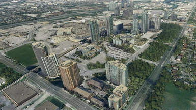
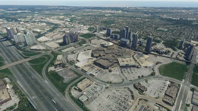
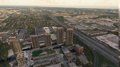
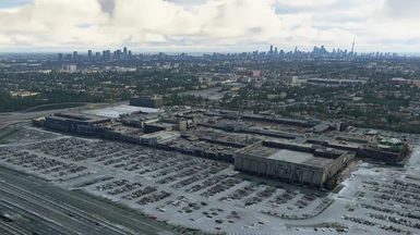
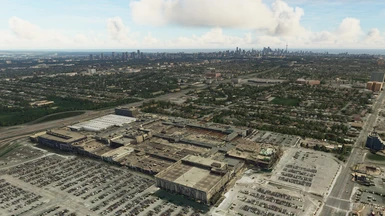
- Mississauga Downtown, Square One mall
- Humber river “aqueduct” ridge terrain fix
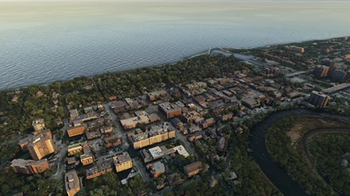
- Oakville Downtown, lighthouse with beacon
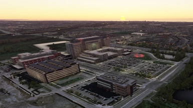
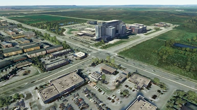
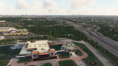
- Oakville Trafalgar Hospital with helipad and surrounding area
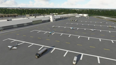
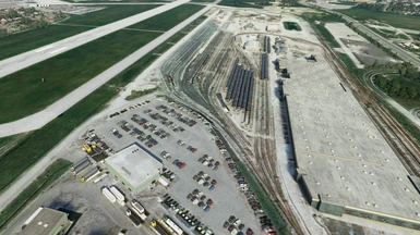
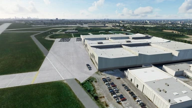
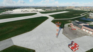
- Downsview Airport CYZD enhancement - cars, buildings, objects etc.
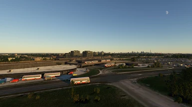
- Wilson Subway Station with custom modeled TTC Buses
- Yorkdale Mall
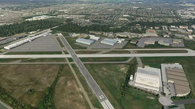
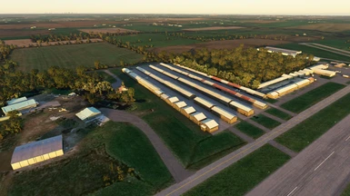
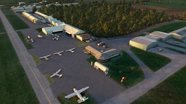
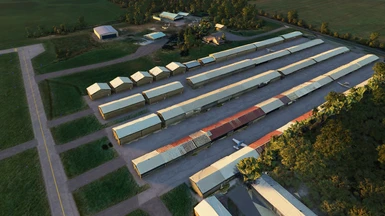
- Burlington Executive Airport CZBA enhancement - photogrammetry, cars, buildings, objects etc.
- Buttonville CYKZ scenery compatibility
- TTC, Go, and Coach Canada buses throughout the GTA
- Cathedral of the Transfiguration, Cathedraltown
- Radio towers with beacons in Missisauga/Oakville areas
- Scarborough City Centre
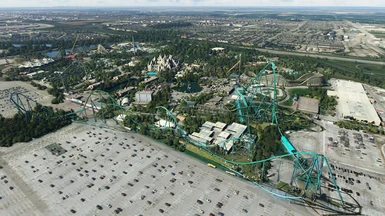
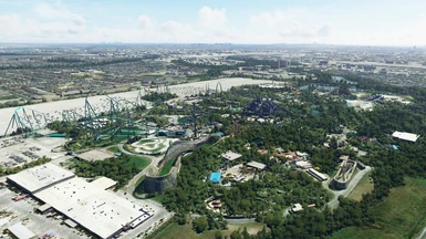
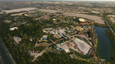
- Canada's Wonderland
- Shri Swaminarayan Mandir
- Exhibition place animated Windmill with flashing night beacon
- David Dunlap Observatory (simplified model - I stopped adding more photogrammetry to Toronto pack to limit the FPS impact)
DONATIONS / SUPPORT
If you want to support my other creative project, check out Progress Report - my sci-fi technothriller novel which you can read and download for free. You can also support my projects through this website usual Donation interface.
INTRODUCTION
The areas of the pack are very close to CYYZ - Toronto Pearson International Airport. Toronto has photogrammetry in MSFS, and Toronto Island CYTZ is a custom airport, but photogrammetry ends outside of Toronto proper, and starts again around Burlington and Hamilton area. Many important Greater Toronto Area VFR landmarks and POI are left to autogen.
I've decided to correct that as much as I can, as well as fix some glaring terrain errors, such as a huge and long weird "aqueduct" type ridge with a Humber river on top.
I'm aiming for making the whole GTA area comfortable for VFR flights and authentic CYYZ approaches and departures, and make local GA flights more enjoyable. So far I've done Oakville downtown and now Missisauga downtown. Meshes optimized and heavily edited, textures color corrected to blend with autogen building.
INSTALLATION
Unzip into Community folder. There are 3 zip files, each corresponds to a major area. They are designed to work together, so install all three. After installation your Community folder should have three new subfolders: /oakville/, /mississauga/ and /toronto/.
DISTRIBUTION
This free creation contains content from Google Maps or Google Earth. In accordance with Google Terms of Services and especially point 2.2 of Google Maps/Google Earth Additional Terms of Service, this creation is based on « fair use » or « fair dealing » of the data provided by google throught its services. No commercial use or any gain is or will ever be made by the author of this creation, who doesn’t own anything regarding google assets but a simple user Licence. According to the following document https://www.google.com/intl/en-GB/permissions/geoguidelines/, the author is freely sharing a creative application of Google Maps or Google Earth. The author will not recieve any form of retribution for sharing his work. If this content would be found somewhere where it is provided in exchange of money or any kind of retribution, I would not be with the consent of the author.
As Google stated it cannot answer to any direct demand about a particular creative use of its properties, like stated in the « written permission » paragraph of the same document, to verify if its complying with its Term of Services, and as it is economically unreasonable for the casual creator of this content to ask for a costly legal analysis of its creation like proposed in the « Fair use » paragraph of the document, the author of this creation will stop sharing it freely and destroy any trace of it at first demand from Google, in accordance with the paragraph « Taking action in case of problems » of the Google Terms of Service about « advance notice » provided « when reasonably possible ».