


This article collects all the ideas concerning the subway project for Fallout 4. An attempt is made to reconcile the real world subway map with the available game world. Unfortunately, not all subway stations can be integrated because the game world is too limited. Some stations were swapped in the game by BGS with or without intent. Subway runner specific maps will be partially revised or disabled and replaced by new subway architecture. As said at the beginning, i try to get as close to the real map as possible.
Rail Lines
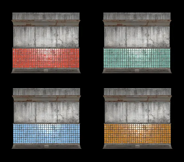
The following rail lines are present IRL. To help navigate the subway network in Subway Runner better, tile color might be handy in the future. There is:
Fandom: Boston MTA
Wikipedia: Rail Lines
- Red (heavy rail line) - https://en.wikipedia.org/wiki/Red_Line_(MBTA)
- Green (light rail system) - https://en.wikipedia.org/wiki/Green_Line_(MBTA)
- Blue (heavy rail line) - https://en.wikipedia.org/wiki/Blue_Line_(MBTA)
- Orange (heavy rail line) - https://en.wikipedia.org/wiki/Orange_Line_(MBTA)
Train Car Length
The length of the subway stations is not so long in vanilla. Assuming 6 cars is the longest train stations will be altered.
- 6 cars (rapid transit)
- 1-3 cars (light rail)
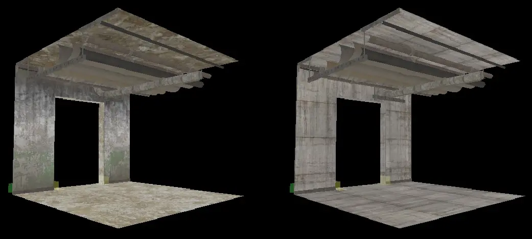
Maintenance | Utility Tunnels
The default utility tunnel network design does not fit what we know and see from real utility tunnels connected to subway lines. Most of the time its huge concrete structures pressed together. Many times the tunnel itself is used as maintenance tunnel. I still try to find a logic on how to extend and mod the current layout.
Left vanilla, right modded:
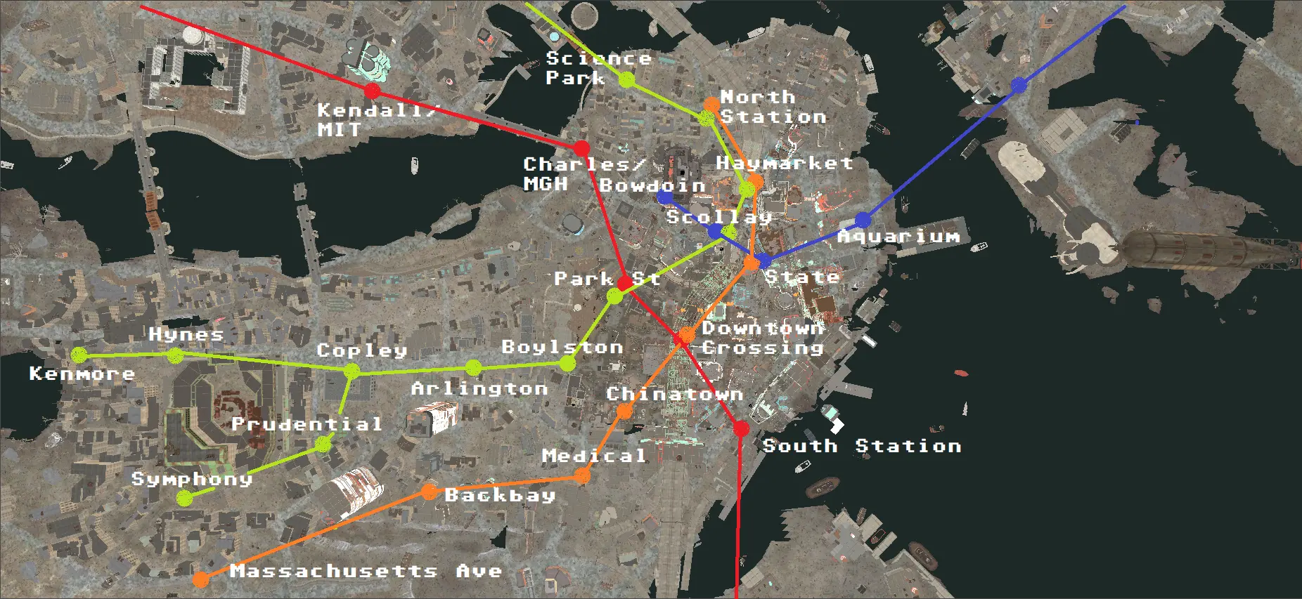
Subway Station List
The following stations are both vanilla and planned stations with the correct line color. Not all planned stations may see light ingame. Let me know which one should.
The red line is very difficult to implement for now, since the real names differ from ingame. College Square would be Harvard Square. CIT Station would be MIT station, etc. Concord and Lexington will probably renamed too.
☑ Red | Concord fandom | ... | removed, was Subway Runner exclusive
☑ Red | Lexington ... | Last station for red line to the north
∟
☑ Red | Nuka-World Transit fandom | ... | no direct connection yet, ingame exclusive station
∟
☑ Red | College Square / Harvard | wiki | fandom | ... | ...
☑ Red | Kendall / M.I.T. / C.I.T. | wiki | ... | formerly named C.I.T. Station, Entrance was moved down the stree to the east
☑ Red | Charles / MGH | wiki | ... | Hub: Blue | planned connection to Bowdoin/Scollay Square
☑ Red | Park Street | wiki | fandom | 1x2 | Elevator | Hub: Green | upper level green, lower level red line
☐ Red | Downtown Crossing / Washington (old) | wiki | ... | Elevator | Hub: Orange | The Dig | upper level orange, lower level red line
☐ Red | South Station | wiki | ... | 3 levels, 2 bus, 3 subway
☐ Red | Broadway | wiki | ... | Elevator | This is the real Andrew Station either the current subway will be renamed or still called Andrew
☑ Red | Andrew | wiki | fandom | 1x2 | Elevator | see Broadway Station, Andrew Station is not correctly added to the game.
☑ Red | JFK / UMass / University Point | wiki | 2x2 | Elevator | ...
☐ Red |
☐ Red |
☐ Red |
☐ Red |
☐ Red |
☐ Red |
☑ Red | Quincy Center / Vault 88 | wiki | fandom | 1x2 | wrong color ingame, two entry points, one inaccessible, untie from Vault 88 connected via 30° arc to Umass
☐ Red |
The blue line was never finised. With the power of the Creation Kit we can. Starting with the connection of Red and Blue at Charles/MGH.
☐ Blue | Charles / MGH | wiki | ... | Hub: Red | Connection to Bowdoin/Scollay Square planned
☐ Blue | Bowdoin | wiki | ... | Connection to Charles/MGH planned
☑ Blue | Scollay Square / Government Center / The Third Rail | wiki | fandom | 2x2 | Hub: Green | Connected to Green/Blue line, two levels
☑ Blue | State Devonshire / Postal Square | wiki | fandom | ... | Hub: Orange | Postal Square is Subway Runner term, interchanges with the Orange Line
☐ Blue | Atlantic / Aquarium | wiki | ... | Entrance via the tunnel, no surface entrance planned
☐ Blue |
☑ Blue | Boston Airport | wiki | fandom | ... | Vanilla cell was split into Ruins (vanilla) and Station (new)
☑ Blue | Revere Beach | wiki | fandom | ... | ...
☑ Blue | Lynn Pier | wiki | ... | ...
☐ Green | Union Square | ... | ...
☑ Green | Lechmere / Monsignor Plaza | fandom | ... | ...
☐ Green | Science Park / West End | ... | ...
☑ Green | North Station / Valenti | fandom | ... | Hub: Orange | Connected to Blue/Orange line
☐ Green | Haymarket | wiki | ... | Hub: Orange | ...
☑ Green | Scollay Square / Government Center / The Third Rail | wiki | fandom | 2x2 | Hub: Blue | Connected to Green/Blue line, two levels
☑ Green | Park Street | wiki | 2x2 | Elevator | Hub: Red | upper green, lower red, Blue Station next to vault 114 entrance is Boylston Station
☑ Green | Boylston Street | ... | Next to Vault 114 entrance and part of Park Street Station
☑ Green | Arlington | ... | Entrance via the tunnel, no surface entrance planned
☑ Green | Copley | fandom | ... | there are two Copley Station entrances, one barred by trash, not sure if it will be linked
∟
☐ Green | Mechanics / Prudential | ... | could replace the vanilla Copley entrance to the south of the library
☐ Green | Symphony | ... | Replaces the current Diamond City station formerly named Fens Way in Subway Runner
∟
☑ Green | Massachusetts / Hynes | ... | Entrance via the tunnel, no surface entrance planned
☑ Green | Kenmore / Fens Way | fandom | ... | renamed
☐ Orange | Oak Grove | ... | ...
☑ Orange | Malden Center | fandom | ... | Upper level orange, lower level train cars in vanilla, seems like a merge short before game release
☐ Orange | Wellington | ... | ...
☐ Orange | Assembly | ... | first station in The Dig, interchanges with the Orange Line
☐ Orange | Sullivan Square | ... | ...
☐ Orange | Thomson Square / Community College | ... | ...
☑ Orange | North Station / Valenti | fandom | ... | Hub: Green | Connected to Blue/Orange line
☐ Orange | Haymarket | wiki | ... | Hub: Green | ...
☑ Orange | State Devonshire / Postal Square | wiki | fandom | ... | Hub: Blue | ...
☐ Orange | Downtown Crossing / Washington (old) | wiki | ... | Elevator | Hub: Red | The Dig | upper level orange, lower level red line, Part of The Dig if entrance from Goodneighbor is used as reference
☐ Orange | Chinatown / Essex | wiki | ... | Elevator | Part of The Dig if entrance from Goodneighbor is used as reference
☑ Orange | Medical Center | fandom | ... | ...
☐ Orange |
☐ Orange |
☐ Orange |
☑ Orange |
☐ Orange |
☐ Orange |
☐ Orange |
☑ Orange | Forest Hills | fandom | ... | The map marker ingame is called Forest Hills but link to West Roxbury Station, concerning map coordinates, Forest Hills is more appropiate.
This is a quick draft of some planned stations and the interconnection of them:
The Dig Subway Map
Current dilemma, the The Big Dig, which of these stations is/are the correct one(s);
- Green:Boylston Station, to far north west
- Orange+Red:Downtown Crossing Station, this is the first station
- Orange:Chinatown Station, this will be the second station
The following spoiler tab will show better what was said in words:
Spoiler: 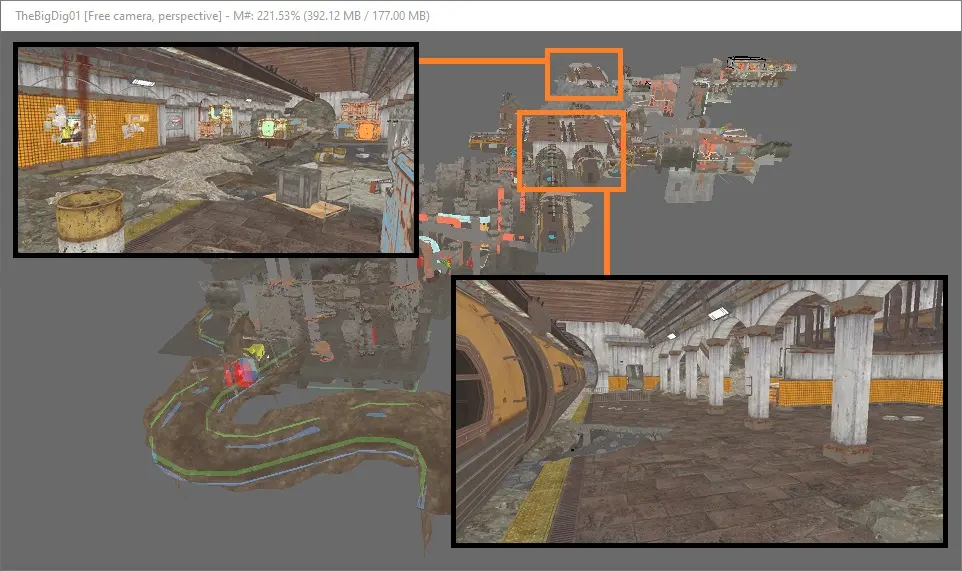

Show
There are two stations for the orange line in The Big Dig. One is an official metro station the second looks like a depot station for chemical, hospital related work.
Please feel free to post any station you would like to see. Feel free to post ideas on how to connect other underground cells, such as Sewers, Tunnels, etc. The big plan is to make an underground network comparable to what we had in Fallout 3.
Reference
- https://www.reddit.com/r/boston/comments/152u60y/someone_was_asking_for_the_3d_renderings_of_mbta/
- The real Big dig project: https://en.wikipedia.org/wiki/Big_Dig
- https://fallout.fandom.com/wiki/Map:Fo4_Commonwealth
- https://fallout.fandom.com/wiki/Subway_Station
- https://fallout.fandom.com/wiki/Boston_MTA
- https://en.wikipedia.org/wiki/MBTA_subway
- https://en.wikipedia.org/wiki/List_of_MBTA_subway_stations
- https://www.mbta.com/history/brief-history-mbta-transit-maps
23 comments
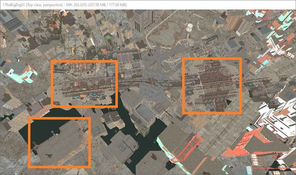
1) Using the entry point and The Dig cell with the LOD map will generate the following stations:
1-1 | Downtown Crossing
1-2 | Chinatown / Essex
2) Using the exit point and The Dig cell with the LOD map will generate the following stations:
2-1 | Back Bay
2-2 | Mass. Ave
Fyi, Medical Center is in between both but not part of The Dig cell at all.
So im more confused than anything else right now and would say the biggest mistake for that game was and is to use real world naming... its horribly setup, plus the fact that we are supposed to have a mistake of 00 for the 200 year mark. That game take place soon after the war considering the decoration etc. probably 2 month or 2 years after Fallout...
I will throw a coin or something since i have no idea how to proceed maybe i will just throw every logic into the trash bin and call the stations whatever i like. Man the planning of the game is just ridiculous.
I've always felt there is too much consumer trash lying around on the ground in the game, if there were any people left they would have used it for scrap materials or burnt it for fuel. We find artifacts from long ago even today IRL, but they are either buried or preserved in attics or cellars and such.
EDIT: I will upload a picutre of the LOD map plus the Dig Interior Cell. So we can plan better ahead.
- Green:Boylston Station,
but if we assume the game design is correct, its an orange line station. So it could potentially be:
- Orange+Red:Downtown Crossing Station
- Orange:Chinatown Station
- Orange:Tufts Medical Center Station (propably not since its Medical Center Station, aka DBHigh)
EDIT: There are two orange stations, one which looks like an official station the second like a depot for the hospital or else. It must be either Downtown or Chinatown.
Here is a link to the Wiki article: Divergence | Fallout Wiki | Fandom
I would suggest as a guideline for names to go by this 1954 map (warning: the north direction faces to the right so it can be a little confusing at first):
2022-01-18-1954-mta-transit-map-collection-otto-m-vondrak.png (2600×1708) (mbta.com)
For stations that we add for places that are in the game but not necessarily on the IRL MBTA, naming them after nearby game landmarks should be fine. There are no IRL MBTA stations in Lexington or Concord for example.
Edit: I'm still thinking about the Big Dig cell and where it fits into all this. I noticed the Goodneighbor manhole doesn't connect right to it in the current version (I think it did before). Do you think anything will eventually be accessible from Third Rail / Scollay? In FROST the tunnel ends are open, but I can imagine changing Third Rail will probably cause a lot of Third Rail mods to be incompatible. Maybe that could be as a separate patch.
Edit2: Just read through the list at the top of this article: West Roxbury station would not be the same as Roxbury Crossing, which IRL is just north of Jamaica Plain. West Roxbury being where it is in the game and IRL makes the current name of that station correct (Note that IRL there is also no MBTA station extending as far as West Roxbury).
alright i will rename the stations i can recognize.
I will have to see how to avoid using the West Roxbury Sign then and check the stations again, i think there should be at least one station between former West Roxbury e.g. Forest Hills and the Medical Center Station (dbhigh).